Leuze-en-Hainaut
Appearance
Leuze-en-Hainaut
Leuze-in-Hénau (Picard) | |
|---|---|
 | |
| Coordinates: 50°35′58″N 3°37′12″E / 50.59944°N 3.62000°E | |
| Community | French community |
| Region | Wallonia |
| Province | Hainaut |
| Arrondissement | Tournai-Mouscron |
| Government | |
| • Mayor | Lucien Rawart (MR) |
| • Governing party/ies | MR, IDEES |
| Area | |
| • Total | 74.46 km2 (28.75 sq mi) |
| Population (2018-01-01)[1] | |
| • Total | 13,886 |
| • Density | 190/km2 (480/sq mi) |
| Postal codes | 7900-7906 |
| NIS code | 57094 |
| Area codes | 069 |
| Website | www.leuze-en-hainaut.be |
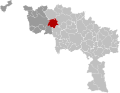
Leuze-en-Hainaut (French pronunciation: [løz ɑ̃ ɛno] ; Picard: Leuze-in-Hénau; Walloon: Leuze-e-Hinnot) is a city and municipality of Wallonia located in the province of Hainaut, Belgium.
On 1 January 2018, it had a population of 13,886.
The municipality consists of the following districts: Blicquy, Chapelle-à-Oie, Chapelle-à-Wattines, Gallaix, Grandmetz, Leuze-en-Hainaut, Pipaix, Thieulain, Tourpes, and Willaupuis.
Famous landmarks
[edit]- The Collegiate Church of Saint Peter was erected in 1745 on the site of a former Gothic church, destroyed by fire. The building's sumptuous interior features intricate woodwork, including the carved Louis XVth style panels of the confessionals, decorated with a variety of motifs, a sculpted representation of Saint Peter in chains, below the pulpit, and the organ casing.

Twin towns
[edit] - Loudun (France) (1961)
 - Ouagadougou Burkina Faso (1968)
 - Carencro, Louisiana (United States) (1993)
See also
[edit]References
[edit]- ^ "Wettelijke Bevolking per gemeente op 1 januari 2018". Statbel. Retrieved 9 March 2019.
External links
[edit] Media related to Leuze-en-Hainaut at Wikimedia Commons


